Submitted by lucas on Wed, 2007-08-01 23:59
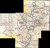
With Erdas Imagine 9.1 we (Henk and I) corrected the files and mosaic-ed them together. Finally ! all the maps together in 1 file.
The Mr. Sid encoded img file is attached below. Irfanview (free image viewer) can display Mr. Sid encoded files.
The yellow bands in the raster file are scanner artefacts. We tried to keep them out of the composed image but on the edges that wasn't possible.
Some more background info:
Submitted by lucas on Mon, 2004-10-25 12:10
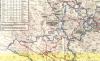
This was the official UN road / route map we had in our ambulance. I've scanned 3 images with the scanner in the office in Busovaca at that time. I don't have the means to ortho-rectify and mosaic them (Henk Kersten did it in 1995 and added 3D data to it to get some real nice overviews (using Leica Erdas Imagine software by the way, see Imagem BV)).
Update (2007-08-10) : we (Henk and I) finally did it: see here for a mosaic. It worked out really well, enjoy !
Submitted by lucas on Mon, 2004-10-25 12:10
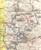
Scan 2 of the UN road / route map, Bosnia 1995.
See:this page for a mosaic of all three map scans.
Submitted by lucas on Mon, 2004-10-25 12:10
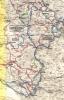
Scan 3 of the UN road / route map, Bosnia 1995.
See:this page for a mosaic of all three map scans.